Sunday, June 29, 2008

Arches NP


Arches National Park
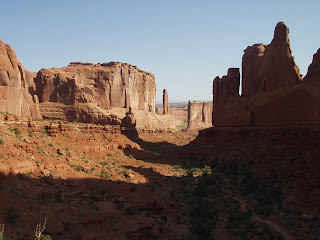
The park lies atop an underground salt bed that is basically responsible for the arches, spires, balance rocks, sandstone fins, and eroded monoliths of the sightseers Mecca. Thousands of feet of salt were in place 30 million years ago. Salt, under pressure, is unstable and as rock formed over the salt beds it was no match for the weight of the rock. The salt layers shifted, buckled, liquefied and repositioned itself thrusting the rock layers upward as domes and whole sections fell into the cavities. There are over 2,000 arches in this park alone. To be classified as an arch it has to be at least 3 feet and it does not matter how thin the arch actually is and as long as you can see light through it. Bob hiked on park ranger guided tour through the Fiery Furnace area. There are no trails in this area and some of the canyons, through the fins, were a tight squeeze and you actually had to position yourself up the rock in order to be able to pass through some areas. The hiking trails brought you close to many of the larger, more notable arches and balanced rocks. There were a number of easy trails that make this park accessible for most people.
Canyonlands NP


Canyonlands National Park
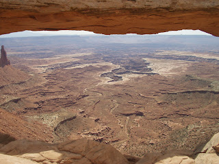
Canyonlands is made up of 3 distinct areas divided by the Green and Colorado Rivers. Island in the Sky is in the northern section with great views of the vast canyons, arches, Green & Colorado Rivers. The southeast area is known as the Needles. The Needles is a startling landscape of sculptured rock spirals, arches, canyons, garbins, and potholes. The dominant landforms are the needles-rock pinnacles banded in red and white. These 2 areas are accessible by 2 wheel drive and do have short, less than 5 mile, hiking trails. The 3rd area called, the Maze, in the southwest corner is one of the most remote areas in the U.S. Canyonlands preserves a wilderness of rock at the heart of the Colorado Plateau. This is, by far, the most wilderness area that we have seen in a National Park in the lower 48. This park is an ideal place for people who want to camp in the back country. Much of the park is only accessible by 4 wheel drive, mountain bikes or hiking. There is always a conflict among park users to keep it remote or to make it more accessible. We hope that they keep this park remote and a true wilderness because enough of it is accessible if you hike a few miles and there is plenty of back country for those who wish to be lost with nature.

Monday, June 23, 2008

Glean Canyon NRA 6/16 - 6/23


Glen Canyon National Recreation Area/Lake Powell
Lake Powell is a lake which was created on the Colorado River for a water supply, reservoir, power generation and recreation. We stayed at Halls Crossing where the daytime temperatures ranged from 102 degrees to 106 degrees. Night time temperatures did get down to the low 70’s. When we were at Glen Canyon Dam we were at the start of the lake and we did, in our travels, reach Hite, Utah which is at the top of Lake Powell. Lake Powell backs up the waters of the Colorado River from Glen Canyon Dam about 185 miles. The area of Halls Crossing and Bull Frog Bay are isolated areas, about 100 miles from the nearest town with a grocery store. Diesel generators are used to supply power to the 2 campgrounds and 2 mariners. There are mobile homes for rent and are used by the employees. This is houseboat paradise. There must be a thousand houseboats between the mariners, rentals and people bringing them in on trailers. Since the lake depends on the Colorado River for water, the lake’s elevation can vary from year to year as much as 50 feet. With this type of variation it is impossible to have beaches for swimming. The houseboats and boats are ideal in order to go onto the lake and be able to swim from. From our standpoint, there was very little to do here. Bob did kayak though and we did take the ferry ride from Halls Cross to Bull Frog to have lunch at one of the 2 restaurants in this immediate area. If you are not a boater this is not area one would want to visit. We now know what it is to be in the desert on a lake with 100 plus degree temperatures.

Natural Bridge Monument 6/18


Natural Bridges Monument
There are 3 natural bridges in close proximity to each other which is the reason that the area was made a National Monument. The bridges were discovered in 1883 and were given various names over time. When the area became a national monument they were given the Hopi Indian names of Owachomo, Sipapu and Kachina. The area’s annual precipitation averages 13 inches and elevation ranges from 5,500 to 6,500 feet. The area is definitely a true desert. The rock in the park, the sandstone, was first formed by windblown sand. The desert streams would occasionally score its beds with a great head of water and sand creating conditions for forming natural bridges. At 10:00 a.m. it was a cool 80 degrees and by the time we left at 3:00 p.m. it was well into the 90’s which felt cool compared to Lake Powell where we were staying which was ranging at about 105 degrees.

Sunday, June 15, 2008

Capitol Reef NP Grand Wash

Capitol Reef NP 6/9 - 6/16


Capitol Reef National Park

A giant wrinkle in the earth’s crust which stretches for 100 miles across South Central Utah is called the Waterpocket Fold. Capitol Reef National Park preserves the fold with its spectacular eroded jumble of colorful cliffs, massive domes, soaring spires, stark monoliths, twisting canyons and graceful arches. We have seen, from the National Parks so far in Utah, the effects of the tremendous forces created by the uplift of the Colorado Plateau. The effects of the forces, from the ice age, uplift, volcanoes, water, and earthquake, make the formations very different from each other. No matter, in which direction you look or what formation you see, they all have a special impression on you as you take in their beauty. This park shows an excellent example of the force of water. As we hiked the Grand Wash Trail it was obvious where the water had cut out the canyon walls. Sue especially liked picnicking in the meadow in an area of the park called Fruita. Mule deer come here to graze and it’s fun watching them while you’re having a picnic. This early settlement was especially attractive to the pioneers who settled here as irrigation was made possible by the flowing of the Fremont River. Indians, who were the first settlers enjoyed this area for the same reason. The Mormon pioneers grew fruit trees such as apricot, pear, apple, cherry and nut trees and to this day some of the original trees are still flourishing This is the only National Park in the country with orchards present on its parcels of land. The Capitol Reef got its name from a massive dome shaped formation which is similar to the Capitol Dome in Washington, DC.

Thursday, June 12, 2008

Bryce Canyon Hoodoos from below

Bryce Canyon Hoodoos from above

Bryce Canyon NP 6/2-6/9


Bryce Canyon

The hoodoo formations are what make Bryce Canyon unique from other National Parks. Bryce Canyon is not a canyon in the true sense because it was not created by a river. The hoodoos are being eroded by the subfreezing night temperatures and relatively warm days resulting in over 200 freeze/thaw cycles annually. Once the canyon erodes, far enough to the west, it will capture the east fork of the Sevier River. Once the river flows through Bryce, all the hoodoos will be toppled and Bryce will become just another real canyon. The views of the hoodoos from the rim and then from the bottom of the canyon gave a completely different color perspective.

When we hiked to the bottom of the canyon we realized how large and fragile the hoodoos actually are. This was one of Bob’s favorite places to hike since you could get down into the canyon within a few miles. The photo with this is at sunset and the colors changed as the sun was setting. Bryce Canyon is the northern point of the Grand Staircase. Looking south, it was obvious that the Grand Staircase is massive. The major points on Bryce Amphitheater were accessible by shuttle bus which made it convenient. The week that we spent there went by very quickly.

Wednesday, June 4, 2008

Pipe Spring


Pipe Spring National Monument
Water is a powerful force in human affairs. Pipe Spring has drawn a succession of people either as an oasis on their journey or as a water source for permanent settlers. The spring is on the Arizona Strip, a vast isolated landscape that lies between the Grand Canyon and the Vermilion Cliffs of Northern Arizona. It’s an arid and seemingly uninhabited region but hidden geological forces have brought water to a few places and this is one of them. The Strip is the first in a series of terraces that step up to the high plateau of Utah some 200 miles north. Water from rain and snow percolate down to a hard shale layer and flow southward to the base of the Vermilion Cliffs where it is forced to the surface at places such as Pipe Spring. The Southern Paiute tribes were living in the area in the 1700’s when Missionaries and explorers visited the area. The Mormons settled in the area in the 1800’s. The cattle and sheep grazing got to the point where the land was not sufficient to handle the great numbers of livestock. The grass in this area, at one time, would tickle the belly of a horse. Between the over use of the land and the drought of 1890, the land is now a desert covered with sagebrush and no grass for grazing. The Kaibab Paiutes have their reservation in this area. They along with the National Parks have established this monument with a museum on site. It was an interesting visit because we got to speak with a number of Paiute Indians. A young woman explained how her ancestors used a Yucca plant and from the roots of this plant made soap, the branches were used to make cords, corsages and baskets and part of the plant such as the flower were used as a food source. She was demonstrating how the root was used for soap and it amazed us how the root when pounded could be used as is by rubbing it in water which makes suds as any soap would. A tribe member, who is a historian, did research and his findings were used in the museum.

Cedar Breaks


Cedar Breaks National Monument
Cedar Breaks Amphitheater is more than 2,000 feet deep and more than 3 miles in Diameter. The scenic drive is along Markagunt Plateau at 10,000 feet. We visited this area on May 31 and at 10,000 feet there was still plenty of snow with the temperature in the 50’s. There were some extraordinary rock forms in the amphitheater with brilliant colors of white, tan and pink. The black rock that one sees along the ride to Cedar Breaks showed the results of volcanic activities in this area in the past.

Glen Canyon Dam


Glen Canyon Dam
This dam created Lake Powell which is the first lake from the Colorado River watershed. As we have previously described, we have visited the other dams below Glen Canyon as we traveled up the Colorado River from Yuma, AZ. When the Colorado River water was divided in 1922 into the lower and upper water districts, Lee’s Ferry was the dividing point. The only lake in the upper district is Lake Powell. The dam is made of a concrete arch structure as is the Hoover Dam. As the other dams, it was created for a water supply
to generate electricity, agricultural needs and recreation. We took a tour of the dam which was very informative. Our visit to Lee’s Ferry showed us the only spot that rafters can put in to float the Colorado River to the Grand Canyon. It is very controlled now with the government only allowing a certain number of trips down the river a year. They are trying to protect the eco system along the River from campers. Bob floated this river sometime between 1973 and 1978. At that time there were a lot less restrictions. Sue had no desire to float the river and Bob will wait until the grand children are old enough to go along with him.

Grand Staircase


Grand Staircase-Escalante National Monument
We decided to venture from Jacob Lake along scenic Highway 89A to Lee’s Ferry then onto 89 to Page, AZ then across Glen Canyon Dam into Utah along 89 to Kanab and back to Jacob Lake. The Grand Staircase extends from the North Rim of the Grand Canyon to Bryce Canyon. The National Monument extends across almost 2,000,000 acres of public land. The best view is from scenic Highway 89 in Arizona. The Grand Staircase is a series of great geological steps ascending northward. The Grand Staircase spans 5 different life zones from the high desert to the coniferous forests. They are known the Chocolate, Vermilion, White, Gray and Pink Cliffs. It took us a while to understand what the Grand Staircase actually is. Bob studied a geological chart of this area and after viewing it from the North Rim North and Bryce Canyon South, it started to sink in. The formation of the rock from 5 different life zones became obvious to him.

North Rim Grand Canyon


North Rim, Grand Canyon
The South Rim and the North Rim of the Grand Canyon are just 10 miles apart with the North Rim being 1000 feet higher. The North Rim at 8,000 ft. is 10 degrees cooler as well. Winter snows close the North Rim and often briefly blanket the South Rim. In order to drive between the North and South Rims requires a drive of 250 miles by road. Sue feels that the views from the North Rim of the Grand Canyon are better than those from the South Rim. Part of this may be the fact that the Colorado River runs along the South Rim. Now that we have visited the South Rim, West Rim and North Rim and if one could choose one to visit by all means they should visit the South Rim for the reasons that it is more commercialized and they have the bus shuttle service available for use. All 3 views are different but outstanding in their own right. The Grand Canyon, over its 277 mile length, varies in width from 8 to 16 miles. The North Rim to the Colorado River is an elevation of 6,000 ft., yet the river is still 2,800 feet above sea level. We did manage to hike along the North Rim but did not venture down into the canyon itself.