Wednesday, April 28, 2010

Old Mission San Juan Bautista


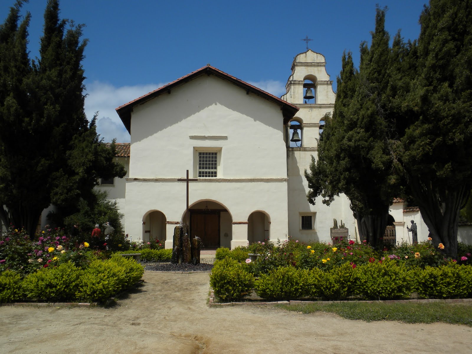
04/28/10 Today we visited the Old Mission San Juan Bautista not too far a distance from Gilroy in San Juan Bautista, CA. It was June 24, 1797 when this Mission was founded by Fr. Fermin de Lasuen, Presidente of the California Missions, successor of the Blessed Juniper Serra. This mission was one of the 4 established by Fr. Lasuen that summer of 1797 and the 15th of the 21 missions in Alta, CA. Largest of all the mission churches, and is still an active parish today, faces the only ORIGINAL Spanish plaza in CA. There is a museum here as well as a gift shop and chapel. The garden area here adjacent to the veranda is just lovely with many rose bushes in bloom similar to the other mission we just visited in Soledad.
In 1817 the interior of the church continued through 1817 when the floor was tiled and the main altar and reredos (which holds 6 statues were completed by a Thomas Doak, an American sailor who jumped ship in Monterey and who painted them in exchange for room and board.
There are rooms off of the “convento” where the museum is where one can see old artifacts from the church, old vestments and even a living room which is displayed that may have looked a lot like that of the Breen family who occupied the mission back in 1847 and called this place home. This family actually survived the Donner Party tragedy.
The Our Lady of Guadalupe chapel is just lovely too. Mass is offered here at noon daily but for some reason the priest didn’t show up for mass today on time and we decided to leave.
We took a walk into town after and had lunch at a local Mexican restaurant, called Casa Esther. It was very good and the servings were generous.

Tuesday, April 27, 2010

Mission Nuestra Senora de la Soledad, CA


Mission Nuestra Senora de la Soledad, CA
We decided to take a ride through the hills and valleys to visit this Mission. This took us through an area which is used for grazing cattle. There were large herds of cattle which makes you realize that, where we are in CA, is a large producer of beef. When you were in the flat land, the farming was obvious. There were miles and miles of fields planted and others being prepared to be planted. The harvesting of ice berg lettuce and romaine were being done and we were familiar with looking at this as we had seen the same thing being done in Yuma, AZ. The wildflowers were in bloom for us all along the way. Sue is keeping track of the many Catholic Missions that we have visited in CA and this one is being added to her list.
This Mission was a small Mission, considered to be in a rural area, when it was established in 1791, even though there were over 2,000 baptisms and 736 marriages performed here.
As with many of the Missions, it fell into ruins during the secular period. In 1954 the Native Daughters of the Golden West and a local group began rebuilding the Mission. This Mission does not have an active parish and Mass is only celebrated once a month at this Mission. The rose bushes around the Mission were beautiful and are cared for by a lady in her 90’s.

Pinnacles National Monument, CA


Pinnacles National Monument, CA
Rock spires, ramparts and crags that bear no resemblance to the nearby foothills dominate the landscape. Massive monoliths, shear walled canyons and boulder covered caves define millions of years of erosion, faulting and tectonic plate movement.
This area was formed when the plates that fit together like pieces of puzzles moved, shifted along fault zones. The San Andreas Fault Zone slices through 600 miles of CA.
Along it, the Pacific and North American plates crush pass each other, one headed north and the other west. The off shore Mendocino fracture zone is the northern most extent of the San Andreas Fault System. The San Andreas Fault is part of the ring of fire, a zone of earthquake and volcanic activity, partly in circling the Pacific Ocean. The activity has formed the Pinnacles.
Someday when we are passing through the area we will camp at the National Monument and Bob will do some hiking. For this trip we just took in the beautiful views, especially the wild flowers.

Daggett, CA


Daggett, CA
We took the opportunity to stop and visit our friend, Ruth, and her son Jack. Ruth managed the KOA Campground in Mount Pleasant, SC up until September of 2009. She became a good friend and was especially good to the grandchildren.
Ruth is an excellent cook and when Sue had her back surgery she supplied us with many of her delicious meals. Bob rebuilt an A- frame pop up trailer for her. It was nice seeing them and her reason for moving back to Daggett was that she grew up there and has now come home. Sue likes diner food and there is a famous diner there in Daggett called Peggy Sue’s. We took Ruth for breakfast there and it was outstanding. Ruth actually worked there as a teenager and it certainly has become a famous landmark to stop at while in Daggett.

Wednesday, April 21, 2010

Deserts


Deserts
We have now had the opportunity to visit the 4 great deserts in the U.S. being: the Chihuahuan, Sonoran, Mojave and the Great Basin. The native Americans, who survived in these areas, were all able to do so with their hunting skills and eventually farming.
The thing that impressed us the most is that no matter where we visited the interpreters all indicated that these native Americans lived in peace. There were some communities where there were upward to 50,000 people inhabiting them. An archeologist found no evidence of any weapons. Until the Europeans introduced weapons, much later, no-one is certain where the original inhabitants eventually went to.

Casa Grande National Monument, AZ


Casa Grande Ruins National Monument, Arizona
The monument preserves the remains of an ancient Hohokam farming village as well as the enigmatic “Great House.” The natives in this area, as well as in the Four Corners, were to be called, “The First Masters of the American Desert.” They were the first to be believed to be hunter gatherers who traveled as their food source traveled. As we have learned there are many edible food sources in the desert and these people took advantage of what was at their disposal. It is believed that as their population grew, they needed constant food sources that were more reliable than what they could just gather. Their farming skills developed. They developed a technique to harness the Gila River through a series of clay dams and canals. They were able to irrigate a large area in which to farm. They dug, by hand, miles of canals. It was an elaborate canal and water field which stood for many years. They developed trade since the village stood in the natural routes between present day CA, the Great Plains, the Colorado Plateau and Northern Mexico.
As with many natives, in this area and the Four Corners, no one is quite certain why they actually moved on. Their existence and their movement from hunter gatherers to farmers has been well established by archeologists but no one has pin pointed the reason or reasons why they moved or where exactly they moved to. We have seen this at a number of sites throughout the Southwest. The “Great House” was a 4 story structure made out of clay.
Its walls faced the 4 cardinal points of the compass. A center hole in the upper west wall aligned with the setting sun during the summer solstice. Other openings also aligned with the sun and moon at specific times. Apparently, the builders of the Great House, people who knew very well the ways of the land, gathered inside to ponder the heavens, knowing the changing positions of celestial objects meant knowing times for planting, harvesting and celebration. These people had to know how to live off of the land or would not have survived living so well until they left.

Mission San Xavier del Bac, Tucson, AZ


Mission San Xavier del Bac, Tucson AZ


Mission San Xavier del Bac, Tucson, AZ
A National Historical Landmark, San Xavier Mission, was founded as a Catholic Mission by Father Kino, a Jesuit priest in 1692. Construction of the current church began in 1783. The oldest, in tact European structure in AZ, the church’s interior is filled with marvelous original statuary and mural paintings. This has been an active Catholic church since the beginning. Someone had the foresight in 1978 to promote the conservation of the Mission Church. Through great efforts, conservators began a five year rescue effort of the interior in 1992. An international team of conservators cleaned, removed over painting, and repaired the interior painted and sculptural art of the Mission.
It is a sight to be seen. The job that was done here shows that with the right experts and enough capital you can restore to the beauty of the original structure. They now have undertaken the restoration of the exterior and are more than half done. Visiting this was a unique experience and we must thank our good friend, Jim Nickoloff, for making us aware of this treasure. The Mission is located on an Indian reservation. On Sundays, the Indians set up grills, which are 50 gallon drums, cut in half and start their wood fires to heat their pots of all types of goodies which they serve on Indian Frybread. This was a real treat. If you are ever in the Tucson area, you must make it a point to visit this Mission Church.
 

Saguaro National Park, Arizona


Saguaro National Park, Arizona
We have arrived in the desert at a great time of the year. Since there was enough rain this winter the desert plants are in full bloom now and are beautiful. There are 2 sections of this National Park, one on the west side and the other on the east side of Tucson. The saguaro has been called monarch of the Sonoran, supreme symbol of the American Southwest and a plant with personality. This is one of Sue’s favorites and they do grow to great size and in some surprising shapes. They may soak up as much as 200 gallons of water from a single rainfall which can last them up to a year. They can swell in size, with added water, so that they can survive up to 2 years without rain. There are over 25 species of cacti in the Sonoran Desert. We did lean a new fact about the jackrabbit, in and that it does not burrow to keep cool in the desert heat, but lays flat under a shade bush.
Saguaros grow very slowly, by year’s end a seedling may measure only l/4 inch. After 15 years it may be nearly 12 inches tall, at about 30 years they begin to flower and produce fruit. After 75 years it may sprout its first branch or arms. Saguaros that live 150 years or more attain the grandest size towering 50 feet and weighing 16,000 pounds or more dwarfing every other thing in the desert.

Saturday, April 17, 2010

White Sands NM, NM


White Sands National Monument, New Mexico
White Sands National Monument preserves a major portion of the world’s largest gypsum dunes fields along with the plants and animals that have successfully adapted to this harsh environment.
The gypsum that forms the white sands was deposited at the bottom of a shallow sea covering this area millions of years ago. This formed gypsum rock and with the uplifts became mountains. Gypsum is soluble in water and normally the rivers would carry it out to sea but the Tularosa Basin, where the white sands are located, do not have any rivers running out. The summer rains and the winter snows bring the gypsum down from the mountains and when the water evaporates it is trapped in the basin. The Southwest winds then move the sands and then forming the dunes. The fine gypsum particles are not rough at all and feel more like talcum power. This is quite the recreation area for the locals as the children have a great time sliding down the dunes.

White Sand Missile Range


White Sands Missile Range - NASA Test Facility
We camped in Alamogordo, New Mexico and this is where the Museum of Space History is located. Much of what was in the museum we had already seen at the Johnson Space Center in Houston. They did have a set-up with the test rails where they did the experiments on humans for G-forces. This was interesting since much of the studies determine what a human being could actually stand in space. It is obvious that this area would be a vacant desert if it wasn’t for the missile range and NASA’s test facilities. Military personnel are the key to the success of this city. They still do testing and the area is still very active. You can see why this area was chosen since it is just a big, vast desert area.

Tuesday, April 13, 2010

Carlsbad NM


Carlsbad Caverns National Park, New Mexico
The Caverns are located in the Chihuahuan Desert of the Guadalupe Mountains. The Caverns, as other caverns, were formed when rain water seeped down through cracks and faults in the limestone. Sue decided to stay above and Bob went below to explore. He has been in enough caves, finally, where he now can spot stalactites, stalagmite, soda straws, draperies, flow stones, columns, popcorn and helictites and identify them. Bob walked down the cave through the natural entrance route which is a mile and descends over 750 feet. He then took the Big Room route which was about a mile. There is a good paved walkway, with handrails, so he was able to do a self-guiding tour.
It was nice to be in 56 degree temperature while in the cave for over 3 hours since the desert is hot even this time of year. They have elevators that you must take out in which you ascend in less than a minute.

Guadalupe Mts TX & NM


Guadalupe National Park, Texas
The Guadalupe Mountains are part of one of the finest examples of an ancient marine fossil reef. A vast tropical ocean covered portions of Texas and New Mexico. Millions of years ago calcareous sponges, algae, and other lime secreting marine organisms, along with lime, precipitated from the sea water, built up to form the 400 mile long horse shoe shape Capitan reef. The sea evaporated. The reef was entombed for millions of years until a mountain building uplift exposed part of it. This is part of the remote wilderness of the American West. To Sue it just looked like a desert mountain range. Even though it is a desert, it gets enough rain fall so that the valleys and the high mountains are covered with some vegetation and trees. Lincoln National Forest abuts the National Park and we took the opportunity to visit Sitting Bull’s Falls which has water flowing over it year round. There are some natural springs in the high forest which supply the water. People are allowed to refresh themselves at the bottom pool which is very welcoming.

Fort Davis Texas


Fort Davis National Historical Site, Ft. Davis, Texas
A key post in the defense system of West Texas. Ft. Davis played a major role in the history of the Southwest. From 1854 to 1891 troops stationed at the post protected immigrants, freighters, mail coaches and travelers on the San Antonio/El Paso road. The fort is one of the best preserved that we have seen. At the peak, there were over 100 structures and quarters for over 400 soldiers. The fort was abandoned in 1891 as a result of the Army’s efforts to consolidate its frontier garrison. It had outlived its usefulness.
The Black Infantry units and the Black Cavalry served on the Southwestern frontier. Some historians think that the Indians named these troops “Buffalo Soldiers” comparing their hair what to buffalo hair and finding them worthy adversaries.
When we were in Houston we visited the Buffalo Soldiers Museum. It gave an insight to their involvement in the Southwestern frontier. We enjoyed the fort because many of the structures were in such good condition and they had a complete bugle corps program that you could listen to while visiting the grounds.

Big Bend NP Texas


Big Bend National Park, Texas
Big Bend refers to the great Southwest Texas U-Turn that the Rio Grande makes here which defines the park’s boundary for 118 miles. This boundary is with Mexico and part of the beauty lies in Mexico. The park includes the river, the desert and the mountains. Rio Grande Village, where the full hook-up campground is located, is over 100 miles to the nearest town. This park would be great if we were 30 years younger and could do the hiking and back country camping that is needed to visit many of the scenic areas. We did get to see a mountain lion which is a rare sighting. Bob was up early in the morning and spotted the mountain lion and Sue was able to see it from the RV. The park being so isolated only gets about 300,000 visitors a year.
We had quite the experience coming into the park. About 3 miles from the village store, we lost air to the rear brakes. Sue prayed and Bob drove into the parking lot safely. It was a large parking lot and he was able to park it safely out of the way. Once he locked the air park brake, he knew that he would not be able to move it. This is when he realized how isolated the area was. We called the road service provider that we have and it took them over 3 hours to find someone to come and tow us. We could not find a mobile service company to come out and do the repairs. Bob knew that it was an air line leak but there was nothing to do except wait for the tow service to come the next day. Bob did go out and explored the park and we were able to camp comfortably overnight in the parking lot. The park staff could not have been nicer about getting us help. The tow company arrived in a big red tow truck, the type that hauls 18 wheelers. Mike and his wife, Dolores, were a nice couple and Mike knew what he was doing. Once we crimped off the air leak and supplied the motor home with air from the tow truck Mike was able to hook it up so that it could be towed. This took a couple of hours. The next thing was finding someone to repair it. Mike was knowledgeable and knew exactly what had to be done. The air line had to be repaired and an exhaust leak fixed. The exhaust leak caused the air line to fail. We were told by the park people that there was someone in Alpine, Texas which was 100 miles who could do the repair. We called the facility and they said to bring it in. Mike, who knew the area, did not believe that the person in Alpine could do the job. We were misled and the person in Alpine did not have the proper facility to handle the job and Mike would not leave it there. He called Ft. Stockton and a one mechanic repair facility said that they could take care of the problem. Off we went for another 60 to 70 miles into Ft. Stockton. This was Friday afternoon and they were not certain as to actually when they could repair it. Once we said that we would pay the overtime rate, it was repaired within 3 hours. The good thing is that we were safe. The repairs were made by a mechanic who knew what he was doing and we were back on the road to a local campground by 7:30 p.m. It was nice to know that the road service that we have pays well because the tow company made certain that we had a repair facility that could handle the motor home before they would leave it. We were just happy that we didn’t have to pay for the tow.

Del Rio Texas


Del Rio, Texas
Amistad Recreational Area - Amistad Reservoir was formed when the Amistad Dam was formed in 1963. The dam was built for flood control, the worst of which occurred in 1954 killing over 300 residents. This was a joint venture with Mexico in accordance to the Water Treaty Act of 1944. Mexico and the U.S. share the water and maintenance of the dam. Each country installed and operates a hydro-electric generating plant. This project ended up with a reservoir and up river water that could be used for recreation. The management of the recreation area was turned over to the National Parks Service in 1965.
The wind was blowing with such force that Bob was unable to go kayaking but we could see the beauty of the recreation area.

Monday, April 5, 2010

San Antonio, Texas


San Antonio, Texas
San Antonio is becoming a city with many outdoor attractions to draw tourists. The Alamo is the one of main attractions where the famous Battle of 1836, for Texas Independence, took place. The ownership of the Alamo went into private hands and the structures were almost totally destroyed. The Daughters of the Republic of Texas, DRT, have been entrusted by the Texas legislature since 1905 of the care and maintenance of this historical site. They are maintaining it as a memorial to the heroes who immolated themselves upon that hallowed ground. The Alamo is definitely a place to reflect on the history of Texas.
In order to supply water to the Missions, along the San Antonio River, canals were built by hand by the Indians. Someone had the vision to turn the canals into a River Walk in the downtown San Antonio area. There are now over 3 miles of the River Walk with many stores and restaurants along this attraction.
The River Walk is below street level. A part of it is boarded by lush gardens and trees. They are extending the River Walk so that there is more area for biking, walking and jogging. In the future they are planning to extend it to include some of the parks in the area.
There are barges which run on the canals to take sightseers. It was a nice trip, lasting about 40 minutes, and the captain gave a good summary on the area.
It was the Girls’ Basketball Final Four in San Antonio. Bob had not seen as many blue and white UCONN hats and shirts in one area since he graduated from college. It was nice to see so many fans supporting girls basketball. If we get the chance we would definitely come back to visit San Antonio again to see what changes have been made.